
Boulevard Towers PUNE, MAHARASHTRA, INDIA, July 16, 2024 /EINPresswire.com/ — BramhaCorp, a distinguished name in real estate with over 40 years of rich legacy, presents Boulevard Towe...

Simplex 3D: Real Estate Visualization Through 3D Modeling

Written by:
Date:
03 Jun 2025
Share via Facebook
Share via Linkedin
Share via X
Copy to clipboard
Twelve years ago, a small team working out of a garage in Israel set out to make complex spatial data easier to understand. Today, their company is changing how entire cities are seen and shaped.
“We started with the idea of making something more simple. That was the idea of simplex, taking something complex and making it more accessible,” explains Avi Aflalo, CEO of Simplex 3D, a company that has quietly revolutionized urban visualization and real estate technology.
Founded in 2013 by Aflalo and two partners with PhDs in computer vision and geoinformation from Israel’s prestigious Technion Institute, Simplex 3D has evolved from a bootstrapped startup into a powerful platform for decision-makers. Its tools are now used by developers, planners, and governments to navigate the built environment with unprecedented clarity.
From Bootstrapped Startup to Industry Leader
Unlike many tech startups that chase venture capital immediately, Simplex 3D deliberately chose a different path. “We had negative experiences in other companies where the focus was mainly on securing funding rather than developing the product or serving customers,” Aflalo recalls. “We decided to develop our own vision, believing that quality work would succeed on its own merits.”
This decision forced the team to be extraordinarily lean. In the early years, the three founders did everything themselves from software development to hardware construction. “My partners, who specialized in software, needed to become hardware experts because our first development was a camera system,” says Aflalo.
Their first clients came from unexpected places: Chile, various African countries, and the United States, before they established themselves as a leading force in Israel for survey and mapping services. By 2016, the company had begun to focus on what would become their specialty: high-resolution 3D modeling.
Setting New Standards in 3D Visualization
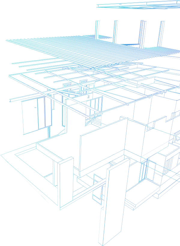
What distinguishes Simplex 3D is their exceptional resolution and scale. “Today, we create the world’s highest resolution 3D modeling for large scale projects,” Aflalo states. “We modeled the five boroughs of New York at three centimeters per pixel, which is unmatched for that scale, not by Google or any other provider.”
This level of detail allows users to make measurements with remarkable accuracy, within two inches or 10 centimeters, eliminating the need for many on-site surveys. But collecting this data is only half the challenge.
“The real difficulty lies in transforming 700,000 images of New York into a realistic, automatic 3D model,” Aflalo explains. “We’ve made that process faster and smoother, with a workflow that’s 95% automatic. We’re likely creating the fastest 3D models outside of Google.”
Democratizing Access to Complex Spatial Data
Perhaps Simplex 3D’s most significant innovation isn’t the data collection or processing, but how they’ve democratized access to this powerful information. “The critical component was making this accessible to everyone, enabling someone with no mapping experience to interact with the map and derive value,” explains Aflalo.
Their SaaS platform streams data quickly over the web, with intuitive tools that make complex geospatial information accessible to non-specialists. “After two hours of training, you can master 80% of the tools. With other GIS software, you need six months to master just 20% of the tools,” Aflalo notes.
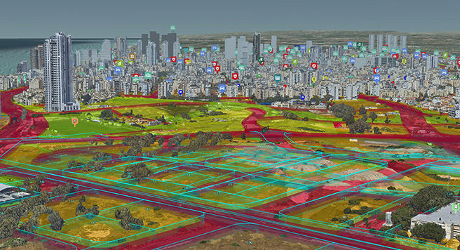
This ease of use has led to remarkable adoption rates. In Israel alone, more than 160 municipalities and government agencies, representing 70-80% of all municipalities in the country, use Simplex 3D’s platform. “In Israel, Simplex is synonymous with smart city planning,” says Aflalo.
From Government to Real Estate: Expanding Market Reach
While Simplex 3D initially focused on government clients for urban planning and security applications, they discovered an untapped market in 2020 when real estate developers, brokers, and architects began reaching out.
“We started receiving numerous inquiries from developers, brokers, and architects saying, ‘We encountered this platform when submitting a project to Jerusalem or Tel Aviv, and we want to use these same tools,'” Aflalo recalls.
This led to a strategic expansion into the B2B real estate sector, with applications spanning the entire development lifecycle:
For Architects and Designers
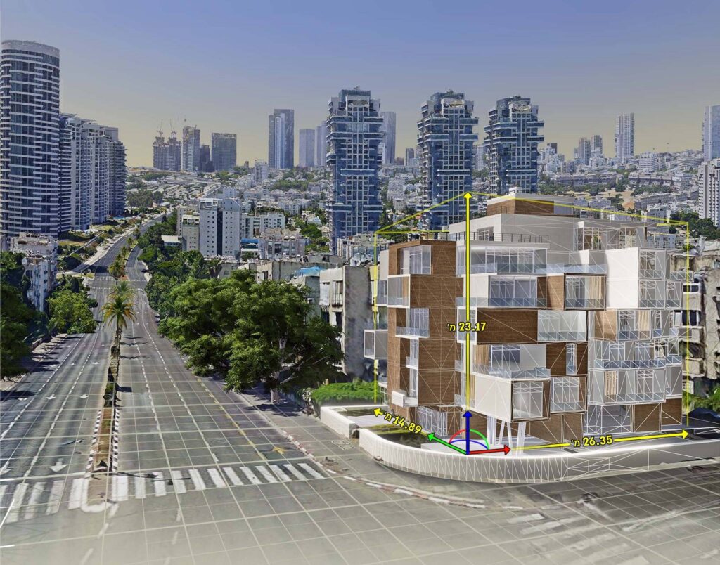
Architects can place their Revit models directly into the urban context, seeing viewpoints from each window, understanding sun exposure and shadow analysis, and measuring distances to surrounding structures. “It functions as a comprehensive design and planning tool,” says Aflalo.
For Engineers and Contractors
General contractors use the platform to coordinate complex projects with multiple stakeholders. “Projects involve numerous advisors and contributors who need to share a common visual reference,” Aflalo explains. “Our platform centralizes that information and makes it visible to everyone.”
For Developers and Analysts
Before a project is even designed, developers use Simplex 3D to evaluate investment opportunities. “Developers and analysts use the platform to assess potential investments, evaluate property purchases, and identify opportunities for value creation,” says Aflalo.
For Sales and Marketing
Perhaps most impressively, Simplex 3D offers a unique solution for marketing new developments. Because they’ve already collected comprehensive 3D data of entire cities, they can generate views from any point in space.
“We have 360-degree views from each pixel on that model,” Aflalo explains. “It’s like having a drone in your pocket that you can release whenever you want in the map. All possible views in the city are already saved within your platform.”
This capability allows developers and brokers to show potential buyers exactly what they’ll see from their future windows or balconies, including views of planned future developments that haven’t been built yet.
Global Expansion and Future Innovations
Simplex 3D has already expanded beyond Israel, with projects in New York, Miami, Portugal, Italy, and other locations. Their compact camera system, “approximately the size of a football”, can be installed on any plane, making data collection relatively straightforward.
“For New York projects, we lease a local plane, send a team with the equipment, install the camera in one day, and complete the collection,” Aflalo explains. “Collecting data for a large city like New York takes a couple of weeks.”
For markets where they haven’t yet collected their own high-resolution data, they’ve developed a second system called REALS (Real Estate Reality), which builds on Google’s data to create marketing materials for new developments. “For projects in Texas or Chicago, I can create a REALS project in a couple of weeks without field visits,” says Aflalo.
The AI-Powered Future of Urban Visualization
Looking ahead, Simplex 3D is working on two major innovations. First, they’re developing new collection technology that will improve data collection efficiency “by a factor of 10,” a significant advancement for their global expansion plans.
Second, they’re leveraging artificial intelligence to transform how users interact with their platform. Since 2022, they’ve been developing AI features to automatically identify everything visible in their 3D models.
“We are training systems to recognize every building feature,” Aflalo explains. “Once accomplished, it functions similar to a simulation game, identifying each building, enabling building replacement, counting windows, quantifying roads, green spaces, and urban infrastructure.”
This automatic identification will enable instant analysis and reporting, as well as the ability to generate entirely new urban models efficiently,” creating detailed urban environments instantly, rather than requiring years of manual work,” as Aflalo describes it.
They’re also developing natural language interfaces that will allow users to interact with the platform through simple prompts. “Users will be able to query the platform directly and receive visual responses,” Aflalo says. “For example, requesting ‘Show me all residential areas in New York with more than five floors in the R6 sector in Brooklyn’ will immediately highlight those areas on the map.”
Similar Articles
Explore similar articles from Our Team of Experts.